Road Signs: A Red Triangle Means Danger Only by Treaty
Codes & Letters
- Published
- Last substantive revision
SymbolSpec card
- Symbol
- Warning triangle with a red border (model Aa)Source: 1968 Convention, Annex 1, Section A
- System
- 1968 Vienna Convention on Road Signs and Signals, compared with the US MUTCDSource: UN Treaty Series vol. 1091; MUTCD 11th Ed. Rev. 1
- Year issued
- 1968 (signed 8 November 1968; in force 6 June 1978)Source: UN Treaty Collection status page XI-B-20, read 2026-10-15
- Design background
- Equilateral triangle, point up, white or yellow ground, red border. The same text allows a yellow diamond with a black rim (model Ab), and each party is to tell the UN which one it uses. The triangle was reserved for danger signs in 1926; the red border was written in by 1949.Source: 1926 Convention Art. 9; 1949 Protocol Art. 11; 1968 Convention Art. 9 and Annex 1
- Image rights
- Diagrams: independent designs, CC BY 4.0. US, German, Swedish and Polish sign drawings: public domain. UK signs: Crown copyright, Open Government Licence v3.0.Source: this page's image credits
road-signs-spec.csv the values on this card, as CSV
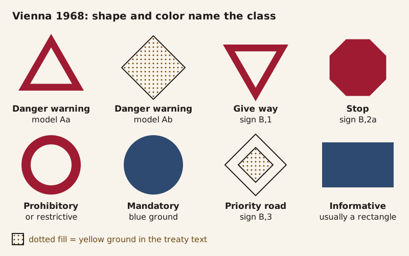
The 1968 Vienna Convention gives each class of sign its own outline and colors. Danger warnings come in two permitted models, a red-bordered triangle or a yellow diamond.
In Germany, Sweden and Poland, a triangle with a red border tells drivers that danger lies ahead. Nothing in the shape itself says so. The meaning was set by treaty, one step at a time, and, on this site's reading, drivers have to learn it like any other code.
The 1909 Paris convention, the earliest treaty on this page, drew its warning signs as round discs. A 1926 convention reserved the triangle for danger signs, and a 1949 protocol gave it a red border. As of 2026-10-15, the United States is a party to neither the 1949 protocol nor the 1968 Vienna Convention. Its traffic manual makes warning signs yellow diamonds, a shape the Vienna text also allows.
When did warning signs become red triangles?
The oldest of the five agreements on this page comes from a Paris conference of October 1909. Article 8 of the convention signed there asked each state to allow only the notices in its Annex D for marking dangerous places, set about 250 meters (roughly 820 feet) before the spot. The annex shows four of them (an uneven road, a sharp turn, a level crossing and a crossroads), each drawn as a dark round disc with a white picture and a French label.
The triangle arrived with the next motor-traffic convention, signed in Paris on April 24, 1926. Its Article 9 put danger signs "on plates in the form of a triangle" and asked each state "as far as possible, to reserve exclusively the triangular form for these signs." Each side had to measure at least 0.70 m, about 28 inches.
 Generated illustration
A country road of the 1920s. The 1926 Paris convention put danger signs on triangular plates and asked states to reserve the triangle for them.
A 1931 convention signed in Geneva, in force from 1934, sorted signs into three classes by outline: triangles for danger, circles for signs "giving definite instructions" and rectangles for signs "giving indications only." It set no color for the triangles. An explanatory note from the League of Nations Secretariat, printed with the text, says the convention "prescribes no special colours" for danger signs and that a border "of any colour is also allowed." The same annex added a point-down triangle, telling drivers to give way at a junction.
The red border was written in by the Protocol on Road Signs and Signals, signed in Geneva in 1949 and in force since 1953. Its Article 11 gives danger signs "a red border with white or light yellow ground" and black or dark symbols. The 1968 Convention on Road Signs and Signals, signed in Vienna and in force since 1978, keeps that triangle as its model Aa. As of 2026-10-15, the UN Treaty Collection lists 40 parties to the 1949 protocol and 75 to the 1968 convention.
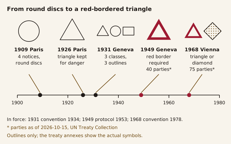
Five agreements, 1909 to 1968: round discs in 1909, a triangle reserved for danger in 1926, three outlines for three classes in 1931 and a required red border in 1949.
Shape first, picture second
Article 8 of the 1968 convention states the design rule outright. The system "is based on the use of shapes and colours characteristic of each class of sign and, wherever possible, on the use of graphic symbols rather than inscriptions." Under its annexes, prohibitory and restrictive signs are circles with a wide red border, and mandatory signs are circles that are normally blue. Informative signs are usually rectangles in which red "must never predominate."
Its Article 5 lists the classes those frames stand for: danger warning signs; regulatory signs, divided into priority, prohibitory or restrictive, and mandatory signs; and informative signs, from direction signs to place names. Annex 2 describes two of the priority signs: the give-way sign, a triangle with its point down, and the priority road sign, a white diamond with a yellow or orange center.
The system works like a two-part code. The frame names the category, and the picture fills in the detail. A driver who knows the code can tell that an unfamiliar triangle is a warning before working out what it warns of. Put the same picture in a different frame and, under the convention, the class changes with it.
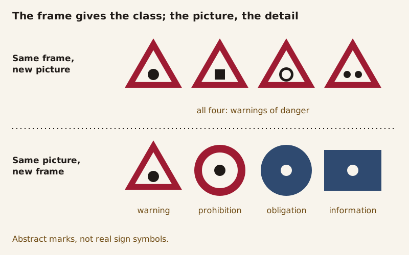
Abstract marks, not real symbols. Four marks inside one red-bordered triangle are all warnings; one mark inside four different frames belongs to four different classes.
None of this is self-evident. In 1909 a warning was a disc, and from 1931 a disc meant an instruction instead. This site's position is that good symbols are learned, not intuitive. The US rulebook says something close to that about its own symbols.
The Manual on Uniform Traffic Control Devices (MUTCD) is the US federal sign manual. Section 2A.09 notes that a change from word messages to symbols sometimes "requires significant time for public education and transition." Its guidance says new warning or regulatory symbol signs should come with an educational plaque, a panel with words, where engineering judgment finds it will help road users understand the sign during the change. The same section says the Federal Highway Administration adopts new symbol designs on the basis of research evaluations of road user comprehension.
Why does the US use yellow diamonds instead?
The MUTCD sets a different code. Its Section 2C.02 makes warning signs, unless the manual says otherwise, "diamond-shaped (square with one diagonal vertical) with a black legend and border on a yellow background." In temporary traffic control zones such as road works, Section 6H.01 turns them orange.
Some outlines carry over between the two systems, and some swap meanings. MUTCD Table 2A-1 reserves the downward-pointing triangle for the YIELD sign alone, the same outline the 1968 text gives its Give way sign. The circle goes the other way. In the Vienna system it marks a prohibition or an obligation, but the MUTCD keeps it for a single warning sign, the railroad grade crossing advance warning (W10-1).
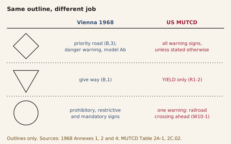
In the 1968 text a diamond marks a priority road or the danger model Ab; in the MUTCD it marks warnings. A circle is a rule under Vienna and a railroad warning in the US.
The 1968 text has a diamond too. Its model Ab is described in nearly the same words, "a square with one diagonal vertical," with a yellow ground and a black rim. Article 46 asks each state to tell the UN which of the two models it has chosen, and as of 2026-10-15 the status page lists 49 such choices: 46 name the triangle and one, Chile, names the diamond. The entries for France and Slovakia are recorded in other forms.
The United States appears in neither UN participant list, for the 1968 convention or the 1949 protocol, as of 2026-10-15. The United Kingdom signed the Vienna convention on November 8, 1968, but the list shows no ratification. Britain acceded to the 1949 protocol in 1966.
| Vienna 1968, model Aa | Vienna 1968, model Ab | US MUTCD, Section 2C.02 | |
|---|---|---|---|
| Shape | Equilateral triangle, point up | Square with one diagonal vertical | Square with one diagonal vertical |
| Ground | White or yellow | Yellow | Yellow (orange in work zones) |
| Border | Red | Black rim | Black |
| Symbols and legend | Black or dark blue | Black or dark blue | Black, as symbols or words |
| Chosen by, UN list of 2026-10-15 | 46 of 49 entries | Chile | Not a party |
Words are the other difference. The 1968 convention prefers symbols "wherever possible." The MUTCD lets state and local agencies write word message warning signs for conditions its standard signs do not cover (Section 2C.02). For its Workers symbol sign, it also lists a word alternative, WORKERS (W21-1a), in Section 6H.18.
The MUTCD's general road-work warning, W20-1, is words only: ROAD WORK followed by a distance or AHEAD (Section 6H.03). Germany's sign 123, Arbeitsstelle (road works), shows a worker with a shovel instead.
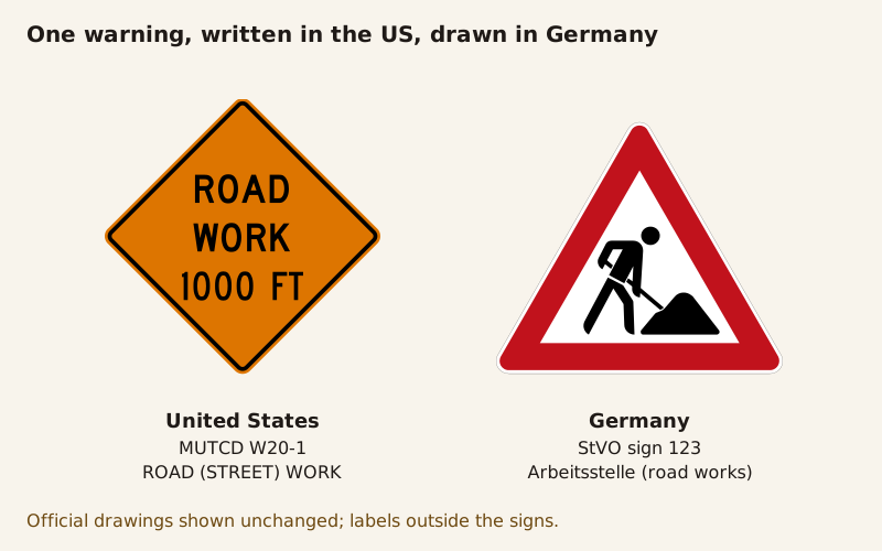
Image credit and license (full text)
"Road works: US word sign W20-1 and German picture sign 123" by Codes & Letters, CC BY 4.0. Source: https://codesandletters.com/symbols/road-signs/. License: https://creativecommons.org/licenses/by/4.0/. Underlying image: "MUTCD CW20-1" by Federal Highway Administration (MUTCD) — Public domain (US federal work; MUTCD Section 1D.06 places traffic control device designs in the public domain and this sign is not among its exceptions; in the EU the rule of the shorter term applies; Commons template PD-USGov-MUTCD) — https://commons.wikimedia.org/wiki/File:MUTCD_CW20-1.svg; modifications: official sign drawings embedded unchanged, scaled proportionally and placed side by side, labels added outside the signs. Underlying image: "Zeichen 123 - Arbeitsstelle, StVO 2013" by Mediatus (after the official German specifications) — Public domain (official German traffic sign listed in StVO Anlage 1, not protected by copyright under Section 5(1) of the German Copyright Act (UrhG); treated in the US as an unprotected government edict; Commons templates PD-GermanGov and PD-VzKat) — https://commons.wikimedia.org/wiki/File:Zeichen_123_-_Arbeitsstelle%2C_StVO_2013.svg; modifications: official sign drawings embedded unchanged, scaled proportionally and placed side by side, labels added outside the signs.

The same job in two codes: the US W20-1 spells out ROAD WORK 1000 FT on an orange diamond, and Germany's sign 123 shows a worker with a shovel.
Same meaning, different drawings
Agreeing on frames did not fix the pictures. Article 8 of the 1968 convention lets parties modify the prescribed symbols as long as the changes do not "alter their essential characteristics," and national drawings differ in posture and detail. The warning for animals on the road shows how far they spread:
- United States, W11-3: a leaping deer on a yellow diamond, labeled Deer in the MUTCD (Figure 2C-15).
- Germany, sign 142: Wildwechsel, a game crossing, with a leaping deer on a white triangle (StVO, Anlage 1).
- United Kingdom, diagram 551: "Wild animals likely to be in road ahead" in the 2016 regulations, drawn as a stag on a white triangle.
- Sweden, A19: "Varning för djur," warning for animals. Transportstyrelsen, the Swedish Transport Agency, notes that other symbols can appear on the sign; the version shown carries a deer on a yellow ground.
- Poland, A-18b: "zwierzęta dzikie," wild animals, as named on its Commons file page, with a deer on a yellow triangle.
In these drawings, Germany and Britain use a white ground and Sweden and Poland a yellow one, and model Aa allows both. Emoji raise the same question of who decides the picture once the meaning is fixed.
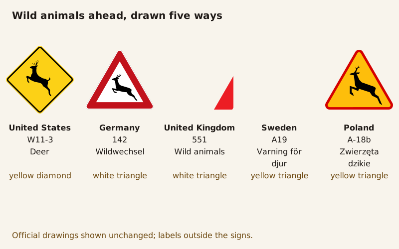
Image credit and license (full text)
"Wild animals ahead: five national drawings" by Codes & Letters, CC BY 4.0. Source: https://codesandletters.com/symbols/road-signs/. License: https://creativecommons.org/licenses/by/4.0/. Underlying image: "MUTCD W11-3" by Federal Highway Administration (MUTCD) — Public domain (US federal work; MUTCD Section 1D.06 places traffic control device designs in the public domain and this sign is not among its exceptions; in the EU the rule of the shorter term applies; Commons template PD-USGov-MUTCD) — https://commons.wikimedia.org/wiki/File:MUTCD_W11-3.svg; modifications: official sign drawings embedded unchanged, scaled proportionally and arranged in a row, labels added outside the signs. Underlying image: "Zeichen 142-10 - Wildwechsel, Aufstellung rechts, StVO 1992" by Bundesanstalt für Straßenwesen — Public domain (official German traffic sign listed in StVO Anlage 1, not protected by copyright under Section 5(1) of the German Copyright Act (UrhG); treated in the US as an unprotected government edict; Commons templates PD-GermanGov and PD-Vz historisch) — https://commons.wikimedia.org/wiki/File:Zeichen_142-10_-_Wildwechsel%2C_Aufstellung_rechts%2C_StVO_1992.svg; modifications: official sign drawings embedded unchanged, scaled proportionally and arranged in a row, labels added outside the signs. Underlying image: "UK traffic sign 551" by Department for Transport (UK Government) — https://commons.wikimedia.org/wiki/File:UK_traffic_sign_551.svg — Open Government Licence v3.0 (https://www.nationalarchives.gov.uk/doc/open-government-licence/version/3/); modifications: official sign drawings embedded unchanged, scaled proportionally and arranged in a row, labels added outside the signs; rights notice: Contains public sector information licensed under the Open Government Licence v3.0. Traffic sign images © Crown copyright. Underlying image: "Sweden road sign A19-2" by Transportstyrelsen (Swedish Transport Agency) — Public domain (Swedish road sign produced by the Swedish Transport Agency (Transportstyrelsen), recorded as free to use by the Commons template PD-Transportstyrelsen; an official road sign, treated as unprotected in the US and the EU) — https://commons.wikimedia.org/wiki/File:Sweden_road_sign_A19-2.svg; modifications: official sign drawings embedded unchanged, scaled proportionally and arranged in a row, labels added outside the signs. Underlying image: "PL road sign A-18b" by Paweł Grzywocz — Public domain (Polish road sign; official signs and symbols are not subject to copyright under Article 4(2) of the Polish Copyright Act of 1994; drawn from a public-domain original; Commons template PD-Polishsymbol) — https://commons.wikimedia.org/wiki/File:PL_road_sign_A-18b.svg; modifications: official sign drawings embedded unchanged, scaled proportionally and arranged in a row, labels added outside the signs.


Animals ahead in five countries: a US yellow diamond and four red-bordered triangles, two on white and two on yellow, each with its own deer or stag.
Walking figures, different meanings
A walking figure in a triangle looks universal, but the official names split two ways. Britain's diagram 544 is "Zebra crossing or Parallel crossing ahead" in the 2016 regulations, and Poland's A-16 is "przejście dla pieszych," a pedestrian crossing, on its Commons file page. Germany's sign 133 is Fußgänger, pedestrians, with no crossing in the name.
Sweden keeps both ideas. Its A13 warns of a pedestrian crossing, "Varning för övergångsställe." A14, "Varning för gående," marks a stretch of road where pedestrians often cross or stay on or near the road, according to Transportstyrelsen.
The US W11-2 is named Pedestrian Crossing. MUTCD Section 2C.55, however, uses its group of signs both ahead of crossings and where pedestrians share the road, and it requires a downward arrow plaque when a post-mounted W11-2 stands at the crossing itself. Section 2C.02 also lets pedestrian, bicycle and playground warnings use a fluorescent yellow-green background instead of yellow.
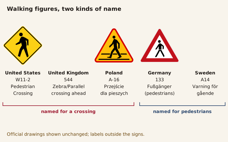
Image credit and license (full text)
"Walking figures with two kinds of meaning" by Codes & Letters, CC BY 4.0. Source: https://codesandletters.com/symbols/road-signs/. License: https://creativecommons.org/licenses/by/4.0/. Underlying image: "MUTCD W11-2" by Federal Highway Administration (MUTCD) — Public domain (US federal work; MUTCD Section 1D.06 places traffic control device designs in the public domain and this sign is not among its exceptions; in the EU the rule of the shorter term applies; Commons template PD-USGov-MUTCD) — https://commons.wikimedia.org/wiki/File:MUTCD_W11-2.svg; modifications: official sign drawings embedded unchanged, scaled proportionally and arranged in a row, labels added outside the signs, bracket labels added below the row. Underlying image: "UK traffic sign 544" by Department for Transport (UK Government) — https://commons.wikimedia.org/wiki/File:UK_traffic_sign_544.svg — Open Government Licence v3.0 (https://www.nationalarchives.gov.uk/doc/open-government-licence/version/3/); modifications: official sign drawings embedded unchanged, scaled proportionally and arranged in a row, labels added outside the signs, bracket labels added below the row; rights notice: Contains public sector information licensed under the Open Government Licence v3.0. Traffic sign images © Crown copyright. Underlying image: "PL road sign A-16" by Paweł Grzywocz — Public domain (Polish road sign; official signs and symbols are not subject to copyright under Article 4(2) of the Polish Copyright Act of 1994; drawn from a public-domain original; Commons template PD-Polishsymbol) — https://commons.wikimedia.org/wiki/File:PL_road_sign_A-16.svg; modifications: official sign drawings embedded unchanged, scaled proportionally and arranged in a row, labels added outside the signs, bracket labels added below the row. Underlying image: "Zeichen 133-10 - Fußgänger (Aufstellung rechts), StVO 1992" by MarianSigler and Mediatus — Public domain (official German traffic sign listed in StVO Anlage 1, not protected by copyright under Section 5(1) of the German Copyright Act (UrhG); treated in the US as an unprotected government edict; Commons templates PD-GermanGov and PD-VzKat) — https://commons.wikimedia.org/wiki/File:Zeichen_133-10_-_Fu%C3%9Fg%C3%A4nger_(Aufstellung_rechts)%2C_StVO_1992.svg; modifications: official sign drawings embedded unchanged, scaled proportionally and arranged in a row, labels added outside the signs, bracket labels added below the row. Underlying image: "Sweden road sign A14" by Transportstyrelsen (Swedish Transport Agency), re-made by Gigillo83 — Public domain (Swedish road sign produced by the Swedish Transport Agency (Transportstyrelsen), recorded as free to use by the Commons template PD-Transportstyrelsen; an official road sign, treated as unprotected in the US and the EU) — https://commons.wikimedia.org/wiki/File:Sweden_road_sign_A14.svg; modifications: official sign drawings embedded unchanged, scaled proportionally and arranged in a row, labels added outside the signs, bracket labels added below the row.


%2C_StVO_1992.svg)

Five walking-figure warnings. The US, British and Polish signs are named for a crossing; the German and Swedish ones are named for pedestrians.
The British image files are numbered under the 2002 regulations, as the Department for Transport's image page notes, and Schedule 1 of those regulations names 544 "Zebra crossing ahead" and 551 "Wild animals likely to be in road ahead." The 2016 regulations (SI 2016/362) keep both numbers: 544 in Schedule 14 and 551 in Schedule 2. The male and female symbols and the peace symbol raise the same question of where a symbol's meaning comes from.
How far away can a road sign be read?
For lettered signs, the US manual gives a ratio. MUTCD Section 2A.08, paragraph 08, says "a minimum specific ratio of 1 inch of letter height per 30 feet of legibility distance should be used." That sentence is Guidance, which the manual defines in Section 1C.01 as recommended practice with deviations allowed, not a mandatory Standard. In metric terms the ratio is 1 to 360, or 1 cm of letter height for every 3.6 m of distance.
In its chapter on guide signs, Section 2D.05 adds that "sign legibility is a direct function of letter size and spacing." Legibility distance, the same section says, has to leave road users enough time to read and understand a sign, allowing for inattention, other vehicles blocking the view, bad weather and poor eyesight.
By this page's arithmetic, 6-inch letters give 180 feet (about 55 m), and a car at 55 mph covers that distance in about 2.2 seconds. The calculation is simplified. It assumes a straight approach at a constant speed and ignores the angle between the driver's line of sight and the sign.
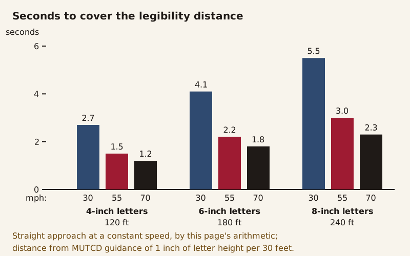
Seconds a vehicle needs to cover the legibility distance at 30, 55 and 70 mph, by this page's arithmetic for a straight approach at constant speed.
The manual's Table 2C-3 suggests how far ahead of a hazard to put a warning sign. Its distances are adjusted for a legibility distance of 180 feet in one condition and 250 feet in another, a figure the table calls "appropriate for an alignment warning symbol sign." Its footnote adds at least 100 feet for warning signs with less than 6-inch legend or more than four words. At 1 inch per 30 feet, 180 feet corresponds to 6-inch letters.
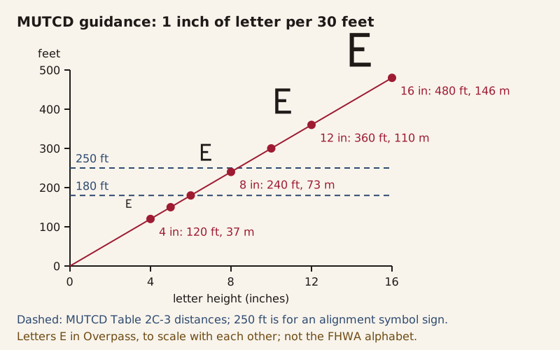
Legibility distance at the MUTCD's guidance ratio of 1 inch of letter height per 30 feet. Sample letters are drawn in Overpass, an open font, not the FHWA Standard Alphabets.
For place names, which the MUTCD prints in mixed case, Section 2A.08 sets the lowercase "loop height" at three-quarters of the capital height. It defines that height by a flat lowercase letter such as x and notes that rounded letters extend slightly above and below it, so that a word looks evenly tall.
How much that lowercase height varies between fonts set at the same size is measured on the x-height ruler.
Sources
- 1
Convention with respect to the International Circulation of Motor Vehicles, signed at Paris, October 11, 1909, Article 8 and Annex D. Treaty Series No. 18 (1910), Cd. 5125. London: His Majesty's Stationery Office, 1910.
https://treaties.fcdo.gov.uk/data/Library2/pdf/1910-TS0018.pdf (full text, Article 8 and Annex D)
- 2
International Convention relative to Motor Traffic, Paris, April 24, 1926, Article 9 and Annex F. Treaty Series No. 11 (1930), Cmd. 3510. London: His Majesty's Stationery Office, 1930.
https://treaties.fcdo.gov.uk/data/Library2/pdf/1930-TS0011.pdf (full text, Article 9 and Annex F)
- 3
Convention concerning the Unification of Road Signals, with Annex, signed at Geneva, March 30, 1931, with the League of Nations Secretariat's explanatory note on the colours of the signs. League of Nations Treaty Series, vol. 150, No. 3459, pp. 247–268 (1934).
https://treaties.un.org/doc/Publication/UNTS/LON/Volume%20150/v150.pdf (pages 247–268)
- 4
Protocol on Road Signs and Signals, Geneva, 19 September 1949, Article 11. United Nations Treaty Series, vol. 182, No. 1671, p. 229 (1953).
https://treaties.un.org/doc/Publication/UNTS/Volume%20182/volume-182-I-1671-English.pdf (English text, Article 11)
- 5
Convention on Road Signs and Signals, Vienna, 8 November 1968, Articles 5, 8, 9 and 46 and Annexes 1, 2, 4 and 5. United Nations Treaty Series, vol. 1091, No. 16743, p. 3 (1978).
https://treaties.un.org/doc/Publication/UNTS/Volume%201091/volume-1091-I-16743-English.pdf (English text, Articles 5, 8, 9 and 46; Annexes 1, 2, 4 and 5)
- 6
United Nations Treaty Collection, Multilateral Treaties Deposited with the Secretary-General, chapter XI.B.20, Convention on Road Signs and Signals: status, participants and designations under article 46(2).
https://treaties.un.org/doc/Publication/MTDSG/Volume%20I/Chapter%20XI/XI-B-20.en.xml (status page as of 2026-10-15)
- 7
United Nations Treaty Collection, Multilateral Treaties Deposited with the Secretary-General, chapter XI.B.3, Protocol on Road Signs and Signals: status and participants.
https://treaties.un.org/doc/Publication/MTDSG/Volume%20I/Chapter%20XI/XI-B-3.en.xml (status page as of 2026-10-15)
- 8
United Nations Treaty Collection, League of Nations treaties, Part II-30, Convention concerning the Unification of Road Signals, Geneva, 30 March 1931: entry into force and parties.
https://treaties.un.org/doc/Publication/MTDSG/Volume%20II/LON/PARTII-30.en.pdf (status page)
- 9
Federal Highway Administration. Manual on Uniform Traffic Control Devices for Streets and Highways, 11th Edition with Revision 1 (December 2025): Sections 1C.01, 1D.06, 2A.05 with Table 2A-1, 2A.08, 2A.09, 2C.02, 2C.04 with Table 2C-3, 2C.55 with Figure 2C-15, 2D.05, 6H.01, 6H.03 and 6H.18 with Figure 6H-1.
https://mutcd.fhwa.dot.gov/pdfs/11th_Editionr1/mutcd11theditionr1hl.pdf (the sections listed)
- 10
Straßenverkehrs-Ordnung (StVO), Anlage 1 (zu § 40 Absatz 6 und 7): Allgemeine und Besondere Gefahrzeichen. Bundesministerium der Justiz, Gesetze im Internet.
https://www.gesetze-im-internet.de/stvo_2013/anlage_1.html (full text)
- 11
The Traffic Signs Regulations and General Directions 2016 (SI 2016/362), Schedule 2, Part 2: Warning signs and associated plates. legislation.gov.uk.
https://www.legislation.gov.uk/uksi/2016/362/schedule/2/part/2/made (sign table, as made)
- 12
The Traffic Signs Regulations and General Directions 2016 (SI 2016/362), Schedule 14, Part 2: Light signals, signs and road markings for the control of traffic. legislation.gov.uk.
https://www.legislation.gov.uk/uksi/2016/362/schedule/14/part/2/made (sign table, as made)
- 13
The Traffic Signs Regulations and General Directions 2002 (SI 2002/3113), Schedule 1: Warning signs, diagrams 544 and 551. legislation.gov.uk.
https://www.legislation.gov.uk/uksi/2002/3113/schedule/1/made (Schedule 1, diagrams 544 and 551, as made)
- 14
Department for Transport. "Road traffic sign images for reproduction." GOV.UK, first published 2013-05-13, updated 2018-01-17.
https://www.gov.uk/guidance/traffic-sign-images (full text)
- 15
Transportstyrelsen (Swedish Transport Agency). "Varningsmärken" (warning signs).
https://www.transportstyrelsen.se/sv/vagtrafik/trafikregler-och-vagmarken/vagmarken/varningsmarken/ (full text)
- 16
Transportstyrelsen (Swedish Transport Agency). "Varning för djur" (A19, warning for animals).
- 17
Transportstyrelsen (Swedish Transport Agency). "Varning för gående" (A14, warning for pedestrians).
- 18
Wikimedia Commons. "File:PL road sign A-16.svg," file description: Polish road sign A-16, "Przejście dla pieszych."
https://commons.wikimedia.org/wiki/File:PL_road_sign_A-16.svg (file description page)
- 19
Wikimedia Commons. "File:PL road sign A-18b.svg," file description: Polish road sign A-18b, "Zwierzęta dzikie."
https://commons.wikimedia.org/wiki/File:PL_road_sign_A-18b.svg (file description page)
Download the data: letter height and legibility distance (CSV) (Data: Manual on Uniform Traffic Control Devices, 11th Edition with Revision 1, Federal Highway Administration (https://mutcd.fhwa.dot.gov/kno_11th_Editionr1.htm), public domain, retrieved 2026-10-15) · equivalent warning signs in five countries (CSV) (Data: Manual on Uniform Traffic Control Devices, 11th Edition with Revision 1, Federal Highway Administration (https://mutcd.fhwa.dot.gov/kno_11th_Editionr1.htm), public domain, retrieved 2026-10-15; Straßenverkehrs-Ordnung, Anlage 1 (https://www.gesetze-im-internet.de/stvo_2013/anlage_1.html), official German legal text not protected by copyright, retrieved 2026-10-15; The Traffic Signs Regulations and General Directions 2016, SI 2016/362 (https://www.legislation.gov.uk/uksi/2016/362), Open Government Licence v3.0, retrieved 2026-10-16; The Traffic Signs Regulations and General Directions 2002, SI 2002/3113, Schedule 1 (https://www.legislation.gov.uk/uksi/2002/3113/schedule/1/made), Open Government Licence v3.0, retrieved 2026-10-16; Transportstyrelsen, Varningsmärken (https://www.transportstyrelsen.se/sv/vagtrafik/trafikregler-och-vagmarken/vagmarken/varningsmarken/), official sign names, retrieved 2026-10-16)
Corrections
No corrections yet. Report an error through the corrections address in the page footer; every change is logged here as YYYY-MM-DD — what changed and why.
Decode next:
- X-height: how tall lowercase letters stand at the same point size in different open fonts, measured from the font files.
- Peace symbol: a circle and three strokes whose meaning, by its designer's account, came from two semaphore letters.
Cite this page
Codes & Letters. “Road Signs: A Red Triangle Means Danger Only by Treaty.” Codes & Letters. Published 2026-10-16. Last substantive revision 2026-10-16. https://codesandletters.com/symbols/road-signs/. Accessed [the date you read it].